Wonderful Historical Walks in Yamba
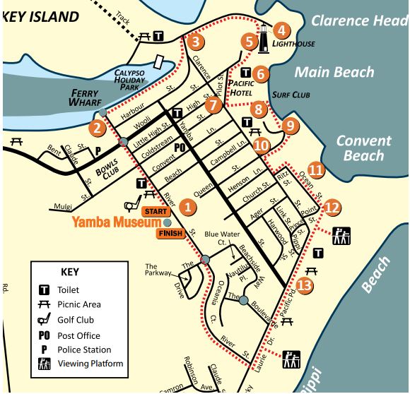
Walk 1 - Up, down and all around
A pleasant 4km, medium-grade walk to view historical sites on Yamba Hill.
This walk takes approximately two hours.

1. Stand outside the Museum and look across to Story Park, given its name from The Story House, as the Museum was once called. The Flagstaff was used at the Pilot Station to display signals to control the movement of vessels in and out of the river thus ensuring their safe passage.
2. Walk along River Street towards Ferry Wharf, where you can take a ferry across to Iluka. Turn right along the Clarence River Walk, passing Calypso Holiday Park. The site was reclaimed by filling in the large bay which was called Billy Blacks Bay. Billy’s father, Walter, built the town’s first hotel, the Wooli Hotel, which operated from 1862 until 1911.
3. Continue following the concrete path to Whiting Beach. Opposite the beach is an information plan illustrating the construction history of the Harbour Works.
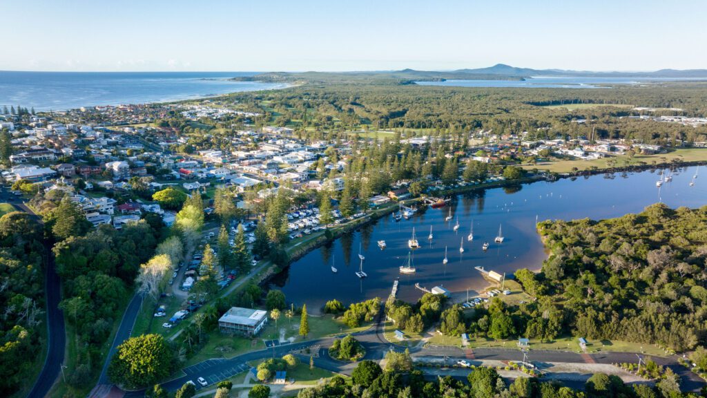
4. The path leads to Turners Beach and the carpark beneath the lighthouse. This area was quarried for the construction of the Southern Breakwater and Training Wall during the first phase of the Harbour Works in the 1860s, 1870s and 1880s. The part of the Training Wall near the Marina is called the Gantry Wall, named after the Public Works Department Wharf where a huge gantry crane lifted rocks and concrete blocks from barges onto a train for the extension of the Southern Breakwater during the third phase of the Harbour Works in the 1950s and 1960s. The Training Wall stretches from the marina to the ocean. A rock swimming pool occupied this site from 1953 to 1968. The pool was used for a family competition during the first famous “Tim The Bream” fishing contest of 1958.

5. Take the Rotary Steps up Pilot Hill to the Pilot Station, on the same site where operations commenced in 1854, and view the remaining Boatmens’ Cottages dating from 1903. The current Yamba Lighthouse was built in 1955. Nearby is the Matthew Flinders Memorial Plaque unveiled by the Governor of NSW in
1999. Next to the reservoir is a replica of Yamba’s first lighthouse (1879) which was completed in 2012 by the addition of the light. It now houses the Community Radio Station 2TLC-FM.
6. Walk along Pilot Street to the Pacific Hotel. First built in 1934, it was almost completely destroyed by a landslide after heavy rain and strong winds in
1950 and rebuilt in a similar form to the 1934 building. It is a good example of the then-popular Art Deco style of architecture.
7. Across the road from the roundabout in Clarence Street is a cluster of restaurants where Fred Phillips’s Kiosk and Saxby’s General Store were the leading shops in town during the 1930s and 1940s. Opposite is the StellaMotel that was built in 1970. The Sisters of Mercy purchased cottages here for a convent and primary school when they moved from a site farther southeast in Clarence Street in 1909.
8. At the southern side of the hotel continue down the Zigzag path to Main Beach. Prior to the 1930s it was known as Graham’s Beach after Mrs Graham’s Ocean View Boarding House which was situated just north of the Pacific Hotel. Walk down to the Yamba Surf Life Saving Club, the oldest continuous country surf club in Australia, beginning in 1908. The Beach Swimming Pool was built in the late 1960s.
9. Take the wooden steps or paved road up to Queen Street. The Cenotaph was originally erected in 1923 near the corner of Wooli and Yamba Streets then moved to its present site in 1946. Opposite are Craigmore and The Cove Units, the sites of two famous guest houses of the 1930s and 1940s era, Craigmoreand The Hotel Ritz. The Hotel Ritz burned down in 1950 and Craigmore was replaced by the present block of units in 1968.
10. Walk up to Clarence Street. The tennis courts on the corner were built in 1931. FlindersPark, named in 1930, was used for camping until about 1960 when commercial caravan parks became established.
11. Turn left and left again into Ritz Street and right into Ocean Street. Below is ConventBeach, formerly McKittrick’s Beach. The Sisters of Mercy established a conventabove the beach in 1900. In 1909, the convent was moved to a more convenient location near Pilot Hill as previously described. J.T. McKittrick purchased the property, including the old convent, and encroaching sands forced him to build a cottage closer to the beach. McKittrick’s last cottage was destroyed by fire in 1927. At the southern end of Ocean Street is Lovers Point, a favourite place for young day trippers coming to Yamba on the riverboats from Grafton between the late 1800s and the 1940s.
12. Enter Ager Park, named after William Ager, the man who saved Yamba from being engulfed by destabilised sand hills in the 1930s. His story with dramatic photos can be viewed at the Museum. In 1989 the Port of Yamba Historical Society buried a TimeCapsule here to celebrate the Bicentenary.
13. Turn left into Pacific Parade and walk along the grass strip above Pippi Beach to Dolphin Park and a viewing platform. Sand mining for heavy minerals (rutile, ilmenite and zircon) between 1934 and 1972 left the sands white and further destabilised the area. The rocky outcrop at the south (Barri Point), commonly known as Flat Rock, was once used as a fish trap by the First Peoples. Continue on Pacific Parade and turn right into River Street. To the west and south, beyond the Ngaru Aboriginal Village and partly on the golf course, lies the old Yamba Cemetery used from 1860 until 1927. It is now completely buried by sand. Return to the Yamba Museum for more information, historical photographs and displays.
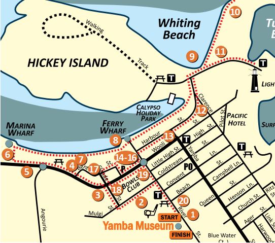
Walk 2 - The sea-level stroll
A pleasant 4km, medium-grade walk to view historical sites on Yamba Hill.
This walk takes approximately two hours.
The above information was kindly supplied by Port of Yamba Historical Society.
Further details on the town’s history can be found in Yamba Museum, River Street, Yamba.

1. Adjacent to the Yamba Museum on River Street is the Yamba Golf and Country Club. The club’s first 3 holes at this site were built in 1956. Walk past Lion’s Park and Yamba Fire Station which opened in 1957.
2. Turn left into Coldstream Street, passing the Sports Oval where the original picket fence was erected in 1936.
3. Turn right into Claude Street. At the intersection with Wooli Street note the fibro cottage at No.57 Wooli Street, the long time residence of the Carr Family.
4. Turn left into Wooli Street to find the One Mile Peg on the right at Fred Phillips Memorial Park. Fred Phillips was a storekeeper, oyster farmer, shire councillor and civic leader in Yamba. The extensive reclaimed parkland was named Ford Park after the local Ford family, who for 39 years from 1930 served on the Yamba Urban Committee, responsible for town maintenance and improvement.
5. Continue west along Wooli Street to the Angourie Road roundabout. The road to Angourie was constructed on the alignment of the railway line from the Angourie Quarry to Freeburn Island. The railway was used to transport rock for the construction of the Middle Wall and part of the southern breakwater in the 1890s.In the mangroves on the river side of the road is the skeleton of a barge used in the construction of extensions to the breakwaters in the 1950s
6. Walk across a little bridge, head towards the river, turn left at the river and view the Yamba Fishing Fleet. On the left is a plaque unveiled at the official opening of the Boat Harbour. The part of the River Training Wall at this location became known as the Gantry Wall because of the Public Works Department Wharf, where a huge gantry crane lifted rocks and concrete blocks from barges onto a train for the extension of the Southern Breakwater. Return east along the rock wall and to the right, opposite the Angourie Roundabout, is Yamba’s last remaining bay, Pegus Bay.
7. Continue along the concrete track into Ford Park. The park was formed by filling in (Douglas) Blacks Bay and Barclays Bay. The Bays were named after local identities who lived nearby. George Barclay was a pioneer fisherman and oyster farmer whose Bent Street house can still be seen behind the park.
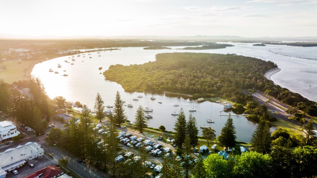
8. Walk past the Ferry Wharf to Calypso Holiday Park which stands on land reclaimed from Billy Blacks Bay. Billy’s father, Walter, built Yamba’s first hotel called the Wooli Hotel.
9. Go past the Calypso Holiday Park. To the left is Whiting Beach on Hickey Island facing Shoal Bay. Matthew Flinders named the bay in 1799. Opposite the beach is an information plan illustrating the construction history of the Harbour Works. Before the second phase of the Harbour Works was discontinued in 1903, the main channel used for shipping was where the Whiting Beach Carpark now stands. Hickey Island is named after a family who operated an early lluka post office, store and boat service.
10. Continue onto the Breakwater. Turners Beach on the right was named after the works paymaster, Turner Turner, who drowned here in 1901. To the left is the T Piece jutting out into the river. The T Piece marks the end of the breakwater in 1887.
The extension was constructed in the 1950s.
11. Returning, take the path left and walk to the carpark beneath the Lighthouse. This is the site of the first quarry used in the construction of the Harbour Works 1862-1903. It became a rock swimming pool in 1953 and the site of the famous ‘Tim The Bream’ fishing competition held in 1958.
12. Return to Harbour Street. On the left is a memorial erected by the Port of Yamba Historical Society on the site of a filled-in spring, known as Flinders Well. It is believed that Matthew Flinders took on water here when he landed in Yamba on 12th July 1799. Just along from here at No.7 Harbour Street is the site of the Wooli Hotel 1862-1911.
13. The Ritz Building and Spar Supermarket are on the original site of the Pacific Hotel opened by Captain William Mann in 1873. Maggie Buchanan’s Boarding House was built next door in the 1870s.
14. Continue along Harbour Street, left into River Street, then right into Wooli Street lined with Norfolk Island Pines. From 1913 to 1949 the old home at No. 39 was used as Yamba’s Post Office.
15. The School of Arts Hall (now the Yamba Library site) was the town’s social venue for dances, public meetings and farewells from 1907 to 1982.
16. The Heritage Listed Yamba Police Station was built in 1903 and extended in 1977.
17. Turn right into Claude Street. The resident Engineer’s office and residence from1888 stood here on the bank of the Clarence River.
18. Walk back along Wooli Street to Yamba Bowling Club. The first clubhouse was built in 1937. The club expanded progressively, purchasing the adjoining land after Yamba Public School moved to Angourie Road in 1990.
19. The School Master’s Residence from 1892, now heritage listed, is located at the corner of Wooli and River Streets.
20. Turn right into River Street to head back to the Museum. Opposite the Museum is Story Park. Situated in the park is a Flagstaff once used on Pilot Hill to display signs to control the movement of vessels in and out of the river.


